Today’s walk from Abingdon to Wallingford is 13.5 miles and starts and ends in two of the most picturesque Thames side towns.

Today’s walk was quite difficult in 36° heat most of the day. Leaving Abingdon along the bank opposite the town provides a beautiful view of St Helen’s church and the alms-houses, some of which were built in 1446.


Round the first bend brings you to Culham Cut and eventually to Culham Lock. The Culham Cut was built in 1809 as a diversion of the river from a notoriously difficult stretch to navigate.


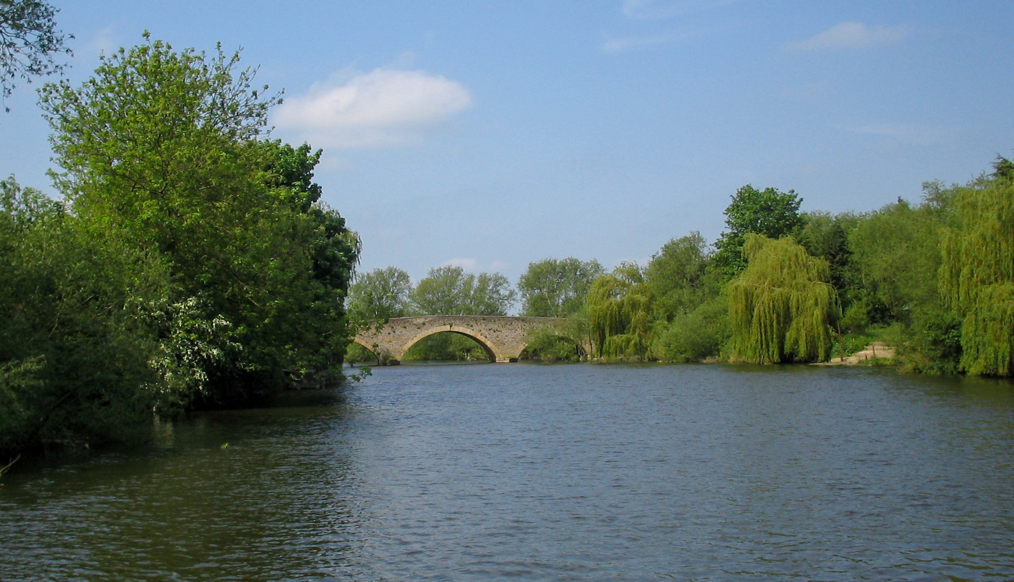
At the Grade II listed mediaeval Culham Bridge built between 1416 and 1422 to replace an ancient ford.
During the English Civil War the bridge had considerable strategic importance. After the Royalists left Abingdon in May 1644 the Parliamentarians seized Culham Bridge, and harried the royalist food convoys on the way to Oxford. The Royalists tried to recapture the bridge and demolish it in January 1645. This resulted in a skirmish on 11 January known as the battle of Culham Bridge. Sir Henry Gage “while boldly leading his men in a third assault on the enemy… was hit by a bullet and killed”.
wikipedia
you can visit Culham or Sutton Courtenay, both small villages but for me there was a particular draw to Sutton Courteney: the grave of Eric Blair, better know as George Orwell. Take the footbridge across the Thames and follow into the village toward the church.


The churchyard is the burial place of Eric Arthur Blair (1903–50), better known by his pen name George Orwell. As a child he fished in a local stream. He requested to be buried in an English country churchyard of the nearest church to where he died. However, he died in London, and none of the local churches had any space in their graveyards. Thinking that he might have to be cremated against his wishes, his widow asked her friends whether they knew of a church that had space for him. David Astor (whose grave is behind Blair’s) was a friend of Orwell and was able to arrange his burial in Sutton Courtenay, a “classic English country village” which Orwell had specifically requested, as the Astor family owned the manor of Sutton Courtenay.
Getting back to the path you soon join up with the main river flow, and looking back get a distant view of the Grade II listed Sutton Bridge built in 1807.
Shortly after Sutton Courtenay, the path goes under a low railway bridge, and a footbridge before passing by Appleford.


At Long Wittenham, the river passes a weir and splits. The river itself meanders along to Long Wittenham. This was a notoriously difficult part of the river to navigate and in 1822 the Thames Navigation Commissioners built the Clifton Cut – a narrow stretch of river diversion which straightens out the meandering Thames up to the Clifton Hampden bridge and Clifton Lock.
The events that led to the building of the bridge started in August 1826 when the Lord Mayor of London made a ceremonial progress down the Thames from Oxford to London. The Mayoral barge grounded on the rocky outcrops in the shallows at Clifton Ferry and was stuck for several hours whilst the weirs further upstream were opened to raise the water level. This episode led to the building of Clifton Lock and weirs in 1835 which allowed better water management on the reach. Whilst the deeper channel was welcomed by river traffic it prevented the fording of the river by herds of cattle and thus prompted demands for a bridged crossing’
Wikipedia


From Clifton Lock the path wends round toward the village of Clifton Hampden, named after John Hampden, cousin of Oliver Cromwell. Here you become faced with the bucolic view of the 12th century Grade II* listed Church of St. Michael & All Angels behind the red brick gothic Clifford Hampden Bridge , built in 1864 designed by George Gilbert Scott this was a toll bridge until 1946. The river is quite shallow here and was the site of a ferry crossing from the 14th century. Just over the bridge is the thatched Barley Mow pub built in 1352 and which features in Jerome K Jerome’s “Three Men in a Boat” described as “the quaintest, most old-world inn up the river“. It was shut when I arrived.


Going over the bridge, the path swaps banks and you are now on a long sweeping curve from Clifton Hampden to Little Wittenham. You go through a gate and down some steps into open meadows, where, way off to the right, you can just make out the two small hills – the Sinodun Hills or Wittenham Clumps. The three mile curve of the river between Clifton Lock and Day’s Lock takes you to the foot of the Clumps so you can measure your progress. Although officially the Sinodun Hills, the Wittenham Clumps refers to the beech tree plantings at the top, “the oldest beech tree plantings in England, dating to the 1740s“. They are situated in the 250 acre Little Wittenham Nature Reserve, a designated Special Area of Conservation managed by the Earth Trust. The second hill which gradually comes into view as you approach, is the site of an late Bronze Age/Iron Age fort.


At the foot of the Clump, is Day’s Lock, the path crossing first the Weir, then the lock. At Day’s Lock you again switch banks and you soon come to Little Wittenham Bridge, which you go under, but don’t cross. The Bridge links to an island on which stands the lock house. This is the finishing line for the World Pooh Sticks Championship which has been running annually since 1984.


Half a mile on from the bridge, you come to Overey Head Piece and then a footbridge over the River Thame which feeds into the Thames at this point. Shortly after, the path diverges from the river for a short while along the A4074 through Shillingford, past the Kingfisher Pub (also closed) down to the beautiful Shillingford Wharf, where you turn left by Shillingford Court, and be stunned by the markers of previous floodlines on the wall. The highest flood level was January 27 1800, when it was some 3 metres high.


A short distance later you come to Shillingford Village and Shillingford Mill before seeing Shillingford Bridge, on the other side of which was Shillingford Bridge Hotel – which was open, and is a nice place for a drink (or lunch) before the last leg into Wallingford.


The path then leads you to the town of Benson and its Benson Cruiser Station where you will find large number of boats and cruisers, as well as the Waterfront Cafe before crossing the weir and lock gates of Benson Lock.


Very soon you see the spire of the Grade II* listed St Peter’s Church in Wallingford. The church was declared redundant on 1st May 1971, and was vested in the Churches Conservation Trust (website here) on 26 July 1972
Next, pass the ruins and site of Wallingford Castle. There is not a lot to see other than the sense of significant past events. The castle in its time was a major medieval castle, very luxurious, but declared for the king in the Civil War. As a result of backing the losing side, Oliver Cromwell had it demolished. The path leads to the attractive Wallingford Bridge, past the riverside Gate House Pub and onto the High Street. Turn right off the bridge and the path continues down Thames Street on the left.


However I carried on to The George Hotel, a 16th century coaching inn were I stayed for the night.


Today was the hottest day of the year, and the river at Wallingford was packed – but a storm was brewing and shortly after these were taken I was forced to take refuge under the white umbrella on the left whilst the thunderstorm passed.


Wallingford‘s early claim to fame is with the surrender of Stigand to William the Conqueror in 1066, which led to his taking the throne and the building Wallingford Castle in which stood at the entrance for 600 years until Oliver Cromwell pulled it down in 1652.
it’s recent claim to fame is as the original location of Causton, home to main character Detective Chief Inspector Barnaby, from Midsomer Murders, who is often seen wandering around the central Market Place or driving across Wallingford bridge. However some might prefer the fact that Agatha Christie lived in the area and built Wallingford into many of her books. Also in the Market Place is St Mary-le-More Church and the Town Hall that dates from 1670.


