
Today’s 10 miles followed the north bank of the river past Surbiton, and at Kingston bridge swaps to the south bank passing Twickenham, Richmond and Isleworth, as far as Kew Bridge. I will be staying on the south bank all the way to Slade Green, then coming back to Teddington to follow the North bank through to Trinity Buoy Wharf.
When I reached Hampton Court previously I did not have time to visit the north bank and Hampton, yet there were things I wanted see.
I stayed at the Kings Arms which is a very short taxi ride, or a 5 minute walk from Hampton Court railway station. It actually overlooks the grounds and you can see the maze from the landing.
This is the last stretch of the path that is significantly rural – apart from the final 2 miles at Crayford Ness.
All the photographs of this stretch have been bought together in this 10 minute video
Hampton
After checking into the Kings Arms, I took a walk into Hampton to see it from the north side of the river. I particularly wanted to see Garrick’s Temple to Shakespeare, Alan Turing’s house and the William Roy cannon which marks the beginning of the Ordnance Survey. However, I found more: ancient mileposts, houses lived in by Sir Christopher Wren when he was redesigning part of Hampton Court for William and Mary, the physicist Michael Faraday and actor David Garrick, after whom the Garrick Theatre in London is named.


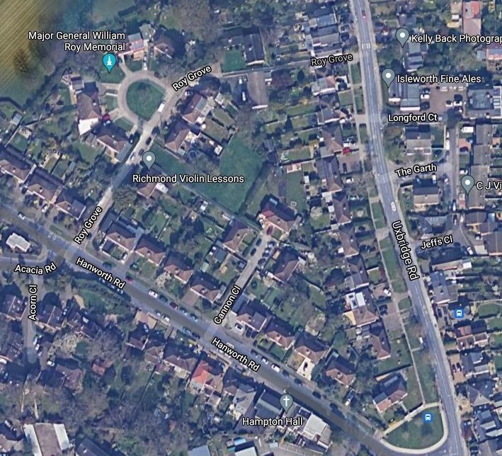
The Major General William Roy Memorial Cannon was a little further than I expected in Roy Grove (TW12 3DN), in the far corner of a rather nondescript close of small detached houses. Roy was born in Lanarkshire, and was an accomplished surveyor and map-maker and in 1765 was put in charge of military surveys in Britain. 1783 the President of the Royal Society commissioned Roy to take charge of an English survey. The spot on Roy Grove where the canon sits was the starting point for that.


After grabbing a meal in Zizi overlooking the Thames, I wandered around Molesey Lock as the sun set behind it, then visited The Albion, The Mute Swan and finished up on the decking on The Mitre as night fell. A lovely spot to end the day.


On To Kew
Hampton Court Bridge is one of 30 bridges (including road, rail and foot) one encounters on this final stage up to the QEII Bridge which one sees off in the distance at the end at Crayford Ness/ Dartford Creek. It carries the A309 and is Grade II listed. The current bridge, designed by Sir Edwin Lutyens, opened in 1933. The first bridge here opened in 1753 and was a toll bridge, the toll house now forming part of the Mitre Hotel


The first 15 minutes are dominated by views of Hampton Court Palace to the left, though mostly of the wall around the grounds. Hampton Court (website here) was originally built by Cardinal Wolsey in 1514, but was confiscated by Henry VIII in 1528 and it went on to become the largest royal palace in Britain. Henry’s son Edward was born here in 1537 at the cost of his wife, Jane Seymour’s, life. Charles I was imprisoned here, and William III and Mary II commissioned Sir Christopher Wren to rebuild part of it. Queen Victoria opened Hampton Court to the public in 1838. On the left is the crenelated Banqueting House built in 1700. There is a splendid view of the gardens from the path through he railings.


The path continues along Barge Walk, past Hart’s Boatyard and Ferry, giving views across to Thames Ditton Island, past some strange cylindrical brick structure and subsequently Raven’s Ait, now an exclusive wedding venue. This was occupied by squatters between 2007-2008 who were evicted in order for the present venue to be developed.


Beyond Raven’s Ait on the opposite bank is the Grade II listed Italianate Renaissance style St Raphael’s Roman Catholic Church built in 1847-8.

The first bridge today and the first major Town is at Kingston. There has been a bridge here since 12th Century but the current bridge was built in 1828. Taking the path across the bridge you come to John Lewis and behind a glass window there is part of a 14th century wall.


Legend has it that the town got its name from the King’s Stone, also called the Coronation Stone, now to be found outside the Guildhall behind blue railings. This is said to be the earliest throne in England on which seven Saxon kings were crowned –
- 902 – Eadweard the Elder
- 925 – Athlestan
- 940 – Edmund I
- 946 – Eadred
- 958 – Edgar
- 975 – Eadweard
- 979 – Ethlered (the Unready)
These took place on the site now occupied by All Saints Church in the centre of Kingston.


At Kingstone the Thames Path swaps banks and we continue on the south bank (which is now on the east side going north!) past a rather quiet riverside plaza, which shortly goes under Kingston Railway Bridge and into 14 acre Canbury Gardens from which there is an attractive vista across the river. These were marshes until it was used for dumping building waste and draining in 1889. This takes us to the first pub of the day, the Boaters Inn, which has a riverside terrace. The path follows a lane and when it veers away is the Half-Mile Tree, a large horse chestnut, planted in 1952 to replace an ancient elm which stood in the same place marking the distance to the centre of Kingston.


As the river bends left for a mile the imposing sight of Teddington Weir and Lock comes into view. It is here, the final pound lock on the river, (Richmond Lock is more a barrier with a lock) and the largest, comprising three locks. It is where the Thames becomes tidal, bringing the unusual and eerie sight from here on of low water, waves lapping the shore and the river flowing upstream when the tide turns. In 1940 a huge flotilla of boats assembled here before taking part in the Dunkirk evacuation. It is the final lock on the Thames managed by the Environment Agency.


A few hundred yards further on is a fenced off obelisk with a plaque “Thames Conservatory Lower Limit” which marks the boundary where the Environment Agency jurisdiction over the Thames ceases and the Port of London Authority (whose website is here) begins.
This heralds a particularity rural part of the path with Ham Lands, a 72 acre nature reserve, originally gravel pits. From here there are great views of the Star and Garter Home on Richmond Hill. Established 1916 to care for disabled soldiers returning from WWI, it was run by a charitable trust until sold in 2013:
The Royal Star & Garter Homes, the charitable trust running the home, announced in 2011 that it would be selling the building as it did not now meet modern requirements and could not be easily or economically upgraded. The building, which is Grade II listed, was sold in April 2013 for £50 million to a housing developer, London Square, which has restored and converted the building into apartments.
Wikipedia
On the north bank is now Twickenham and Eel Pie Island, only reachable by boat or a footbridge on the north bank, a small island with an interesting past. (We return there on the north bank on Day 17). The island was the site of the Eel Pie Island Hotel, which in the 60s hosted bands such as The Who, Rolling Stones, Yardbirds, Davis Bowie, Pink Floyd. In 1969, the club briefly reopened as Colonel Barefoot’s Rock Garden, with bands such as Black Sabbath, The Edgar Broughton Band, Stray, Genesis, and Hawkwind performing there. In 1971 it mysteriously burned down after falling into disrepair. It also features in Dickens’ Nicholas Nickleby. There are some 300 residents including the inventor of the wind up radio, Trevor Baylis, until his death in 2018.
We then see the Grade I listed Ham House to the right, now managed by the National Trust. Built in 1610 and virtually unchanged since 1698, described by the NT as “unique in Europe as the most complete survival of 17th-century fashion and power.”
As we reach Petersham Lodge Woods across the river is the Grade I listed Palladian villa Marble Hill House, sitting in 66 acres of parkland managed by English Heritage. It was completed in 1729 for Lady Suffolk, George II’s mistress. Hammertons Ferry takes passengers between Ham House and Marble Hill House.
The final stretch of the path takes you through Buccleuch Gardens which run up to Richmond Bridge.


Richmond feels very much a riverside town. Its bridge was built in 1774 and is the oldest surviving bridge across the Thames in London itself. Richmond was originally called Sheen where the Manor of Sheen had been a royal residence since 1299. In 1501 there was a fire at the Manor of Sheen and Henry VII, who was Earl of Richmond, rebuilt the palace and named it Richmond Palace after the town in Yorkshire. It has remained Richmond-on-Thames ever since. His son, Henry VIII, was born at Richmond and whose daughter Elizabeth I had the world’s first flush water toilet installed there. She died at Richmond in 1603, presumably .. on the throne.
It remained a residence of the kings and queens of England until the death of Charles I in 1649. Within months of his execution, the Palace was surveyed by order of Parliament and was sold for £13,000. Over the following ten years it was largely demolished, the stones and timbers being re-used as building materials elsewhere. Only vestigial traces now survive.
Wikipaedia
Under one of the arches of the Grade I listed Richmond Bridge is the Tide Tables Cafe with lots of riverside al fresco tables. The bridge had shown itself to be inadequate for the amount of traffic it was taking even after a second bridge at Twickenham was built. After being taken into public ownership in 1931, several proposals were made to widen it, but most were rejected and it was finally agreed to widen it by removing all bricks on the upstream side, increase the width and replace the original brickwork. This took three years between 1937 and 1940, and the join can still be seen under the bridge arches.
After Richmond Bridge comes the Grade II listed Richmond Railway Bridge, and the Grade II* listed Twickenham Bridge which links the Old Deer Park with St Margaret’s. Thre first (Gatso) speed camera in the UK (the yellow box radar type was installed on Twickenham bridge in 1992.


The Grade II* listed Richmond Lock lies a few hundred yards downstream from Twickenham Bridge. Built in 1894 to deal with the increasingly shallow water in the Thames bewtween Richmond and Teddington. It is the final of the forty-five Thames locks and is the only one owned and operated by the Port of London Authority. It consists of three sluice gates which are lowered two hours after high tide and raised again two hours before the next high tide, and a pound lock through which vessels can go when the sluice gates are closed. I got there just as the sluice gates were opening – see video.


Just past Richmond Lock on the far side of the river is the red brick Gordon House. Built in the late 17th Century it has an interesting history, Having had several previous owners in 1895 Gordon House became the first Industrial School for Girls.
It was a boarding school were girls were educated and taught a trade such as cooking, household management, or laundry work. The school closed in 1922 and Gordon House was sold to the Royal Naval Female School. Subsequently Gordon House was taken over by Maria Grey Teacher Training College for Women in 1949 and many local teachers obtained their teaching diplomas there until the late 1970s, when it became part of the West London Institute of Higher Education Both colleges became co-educational and provided degree courses as well as teacher training. A further change occurred in 1995, when both sites became campuses of Brunel University. In 2004 Brunel University put both the Gordon House and the Borough Road site up for sale for housing developments. In 2014 the land between the St. Margaret’s Road and Gordon House was being developed with houses and flats. Gordon House has been restored to its 18th century splendour and was for sale at £25 million.
panoramaofthethames
As Isleworth Ait comes to an end there is a small slipway over the river by a church. This is Church Street Isleworth and the church is All Saints, (website here) close to The London Apprentice public house (website here)- we will return there on Day 17 on the north bank. Church street takes you to the entrance to Sion Park through which the north bank Thames Path passes. The first one sees from the south bank is the pink Syon Pavilion Boathouse which used to belong to Ferry House, once the home of Conservative MP Ian Gilmour. Ian died in 2008 and the house (but not the Boathouse) was up for sale for £3.75 million.
Originally owned by the Dukes of Northumberland, the most famous tenant was the artist J M W Turner from 1804 until 1806. He had completed a watercolour of Isleworth church nearby at the age of 13 when living with his uncle in Brentford
Richmond and Twickenham Times, 14th August 2008
The boathouse was designed by J Mylne in 1788 and until the 1990s the home of Lady Victoria Scott, daughter of Earl Haig. Half a mile further on you get a view of the imposing Grade I listed Syon House, topped with a lion and situated within Syon Park. Syon House is the residence of the Duke of Northumberland designed by Robert Adam in 1760 and named after Mount Zion. Lady Jane Grey was living in the house in July 1553 with her husband when she received news that she was to become Queen. That didn’t end well.


On the south bank to the right of the path is Old Deer Park which was the original hunting grounds for Richmond Palace. There is an obelisk by the path which is a marker of true north from Kew Observatory which can be seen through the trees. The Observatory was originally built to allow George III to view the transit of Venus in 1769, but was transferred to the Meteorological Office in 1867, and was closed in 1980. It is now a private residence.
Along the path is the old Meridian line that was used to set the time before Greenwich was agreed upon internationally. A metal tower with a slot allows you so peek through to see the meridian line.
It is from here the first tower blocks of the city come into view.


About a mile further on across the river is Ferry Wharf, and the entrance to the Grand Union Canal at Brentford where there is a large wave like stainless steel sculpture by Simon Packard. We return to that spot in Day 17 on th north bank.

On the right now though hidden by trees is Kew Gardens, otherwise known as The Royal Botanical Gardens. Opened in 1759, Kew houses the largest collection of living plants in the world in its 300 acres. It also includes the salmon pink Kew Palace, another royal palace, built in 1631 . George III died here, as did his queen Charlotte in 1818. Queen Victoria’s parents were married in the drawing room.

Across the river you can see the tower of the former Kew Waterworks, built in 1867 now housing the London Museum of Water and Steam (website here).

You now come to the steps up to Grade II listed Kew Bridge and Kew Green. When this current bridge was opened in 1903 it was called Edward VII Bridge and the plinth in the centre says so. However, the original name first used in 1759 seems to have stuck.


Kew
I chose to stay in the Coach and Horses, (rated 4.0 on Trip Advisor). This is a fabulous pub with 31 rooms situated in the diagonal corner of Kew Green, next door to the house Camille Pissarro stayed in, and opposite the red brick St Anne’s Church where Thomas Gainsborough is (allegedly) buried.


Kew Green is owned by the Crown Estate and leased to Richmond. Most of the houses surrounding the green are Grade II listed as are the lamp standards, the war memorial and the post box. In the north corner is Elizabeth Gate – a main entrance to Kew Gardens.
Along the the east side is Kew Pond, now a half-acre nature reserve. Originally fed from a creek from the Thames, it is now fed at high tide by local volunteers.


From the bridge looking down stream as the sun sets you can see the lights of Strand on the Green. Tomorrow, off to the city.